Saturday, January 28, 2012

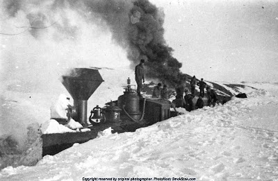
So, how much snow?

Some years are big on snow. Some are not. And 1909 was pretty big. Here's an interesting photo I came across that shows a steam locomotive "stuck real good" in the winter of 1909. It is located somewhere along the run between Lewistown and Buffalo-Judith Gap area (immediately west of Lewistown.) In 1994, when I was the Home & Family Editor of the Lewistown News Argus, I interviewed Red Hanley. Red had worked as an engineer and he told me an interesting story about how he got a steam locomotive stuck in snow along the same run as in the photo. But, unlike this train, Red's was pushing a weighted boxcar with a plow in front instead of just a plow. As I recall, he told me he'd been advised to "give it as much speed as possible" --- he did and the train went pow! right into the snow drift---in, in, in, in, ...in...........in.............in............in.......and then it stopped. It was buried at least as deep as the one in this photo, or maybe more.


Monday, January 23, 2012

Aaaah! The drive home after a day's work. . .


This is the last ten miles before Lewistown (photo above.) Actually, less than ten at this point. It is one of my favorite "road views" The Big Snowies are  on the horizon, the road is bare and dry. The usual amount of "quitin' time" traffic and a freshly brewed (in the car) cup of ginger/lemon tea on the console.

Another photo (below) of today's drive home, taken just at the top of the Arrow Creek Canyon (with, at that point, more than half the drive remaining.) I almost always stop at this field entrance to take photos of the Highwood Mountains and Square Butte, but today I turned the camera to the southwest and captured the late afternoon winter sun and the Big Belt Mountains on the horizon.


Over most of the climb up Arrow Creek Canyon, I got to share the road with some big boys coming down (photo below.) Perhaps a half dozen of these rigs and their multiple advance and rear guard vehicles passed me. I didn't get a very good look at what they were hauling except that all carried an identical load. Perhaps it is something headed for the Canada oil fields. 


And today's drive was not entirely all peaceful and idylic. On the morning leg, a large cock ringneck pheasant made a bad decision and the jeep's passenger side mirror caught the bird. It sounded like something far larger than the bird hit. Had I not seen the pheasant, I would have thought a deer had run into the side of the vehicle. What a loud bang! I was doing 65 mpg. The mirror is designed to "give" and that's exactly what it did (which is cool for this is a 1996 jeep.) The mirror and its housing and manual cable controls were undamaged. Only one little piece on the part mounted to the door actually broke. With that and some assembly, it will be as good as "new" (which is to say, as new as a nearly 20 year old vehicle can be.)


Thursday, January 12, 2012

Long Thin Road


Mr. Lightfoot (Gordon ta dem dat know's 'im) may sing about the "Long Thin Dawn" but here's one for a long thin road. This windshield view is heading east to Lewistown. I'd spent the day, first at Surprise Creek Hutterite Colony and then at Geyser School, teaching art. This photo (above) was taken on the fly somewhere just east of Stanford (No, I don't know what mile marker it was---gotta keep my eye on the road, ya know!) I've long liked this stretch of blacktop. It's one of the few places to have two lanes in the uphill (west-bound) lane. See all the traffic? And it's rush hour too!

This next photo was taken just a little bit farther down the road but before Moccasin. I had to stop and get out for this one. (click on any of the photos for a larger view.) I like the way sunset turns snow to pink on the east horzon. The mountains in this photo are the Big Snowies.


And for the grand finale, one last view of the setting sun. I'm not skilled at sideview mirror photography, so this was a stop too.) This is looking west, as the sun sets behind the Belt Mountains.

Hope you enjoy the views! The land and skyscapes are what keep the drive fresh every time, no matter how many times I've traveled the route before---it is always "new again."


Friday, January 6, 2012

War Horse Reservoir

It has been so warm the past several days (60 degrees F yesterday) that a drive was in order today. Bright blue skies and warm sunshine in January -- how could it be any better?
The end destination for the drive was a reservoir named War Horse northeast of the town of Grass Range. Grass Range is 30 miles east of Lewistown, so War Horse Reservoir is about 45 to 50 miles from where I live. Once you leave the black top just east of Grass Range a very good gravel road takes you north as it arcs slowly back to the west while also heading north. A rougher (but very passable) two-track road takes off into the wind beaten ponderosa pines and eventually leads to the south shore of the reservoir. The clusters of pines are a shale forest and in places on the forest floor a fine shale "soil" is visible. It is an area of critical environmental concern by the Bureau of Land Management (BLM) because of the unique plant community.
The photo below is taken from the road on the south shore looking west. The edge of the reservoir is visible to the far right. The Judith Mountains, with Black Butte on the far right of the string are on the horizon.
(click photos to view larger)


This next photo shows the good gravel road at the point where the two-track takes off (that would be to the right of where I stood to shoot this photo.) I love how roads can seem to have no end in the vastness of the central Montana prairie.


Driving down the road shown in the previous photo, the creek that feeds the reservoir crosses. I was surprised at its size for this time of year, but considering how large War Horse Reservoir is, this creek must carry a lot of water year round.


The following photo is prairie, prairie, prairie -- with the Judith Mountains in the distance to the west.


The next photo is a view farther down the road from the previous photo but looking south. In the distance are the Big Snowy Mountains (also referred to locally as the Big Snowies or, simply, the Snowies) The dished in middle of the Snowies' skyline is Half Moon Canyon.


Hope you enjoyed the photos! Your questions or comments are welcome and I will try to respond to questions within a day or two.